 ar
ar bg
bg hr
hr cs
cs da
da nl
nl fi
fi fr
fr de
de el
el hi
hi it
it ko
ko no
no pl
pl pt
pt ro
ro ru
ru es
es sv
sv tl
tl iw
iw id
id lv
lv lt
lt sr
sr sk
sk sl
sl uk
uk vi
vi et
et hu
hu th
th tr
tr fa
fa ms
ms hy
hy ka
ka ur
ur bn
bn mn
mn ta
ta kk
kk uz
uz ku
ku
Vertical In-Place Inclinometer System
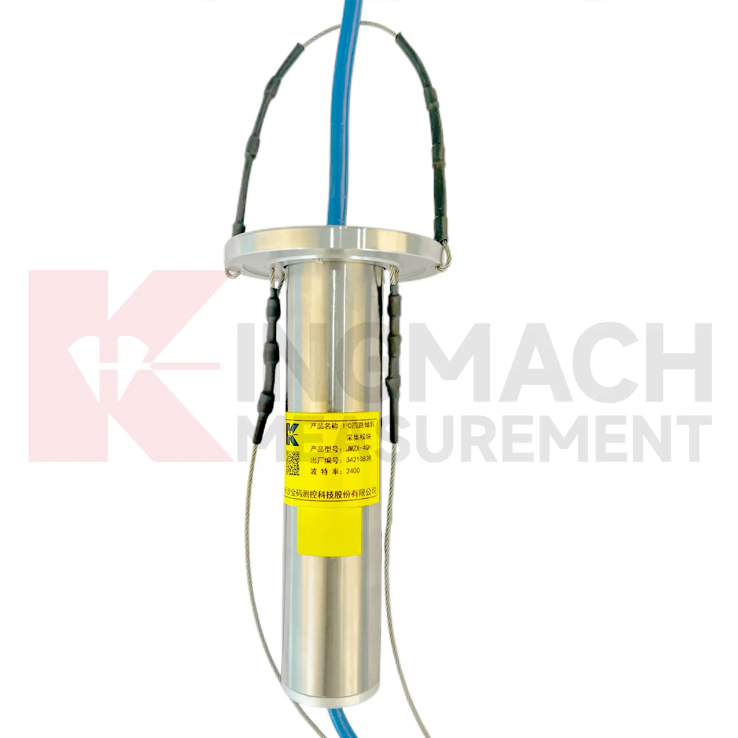
The JMQJ-7915ATS vertical in-place inclinometer system gives Kingmach Vertical In-Place Inclinometer System a multi-point downhole monitoring method. The system consists of a multi-point tandem inclinometer string and an orifice acquisition module. Multiple MEMS inclination sensors are electrically connected through a single cable inside the borehole, while universal joints and connecting rods arrange measuring points according to design spacing. The system can divide sensors into up to four independent communication groups, uses automatic temperature compensation, and includes electronic identifiers for automatic recognition and intelligent calculation. Published specifications include dual-axis +/-90 degrees tilt range, 0.001 degree resolution, 0.01 degree accuracy, DC 9V to 24V operating voltage, power consumption below 0.2W, single-wire uplink communication at 1200 bps, -30 degrees Celsius to +70 degrees Celsius operating temperature, 0.35 m guide wheel spacing, about 0.8 kg weight, and IP68 protection.
Application of Vertical In-Place Inclinometer System
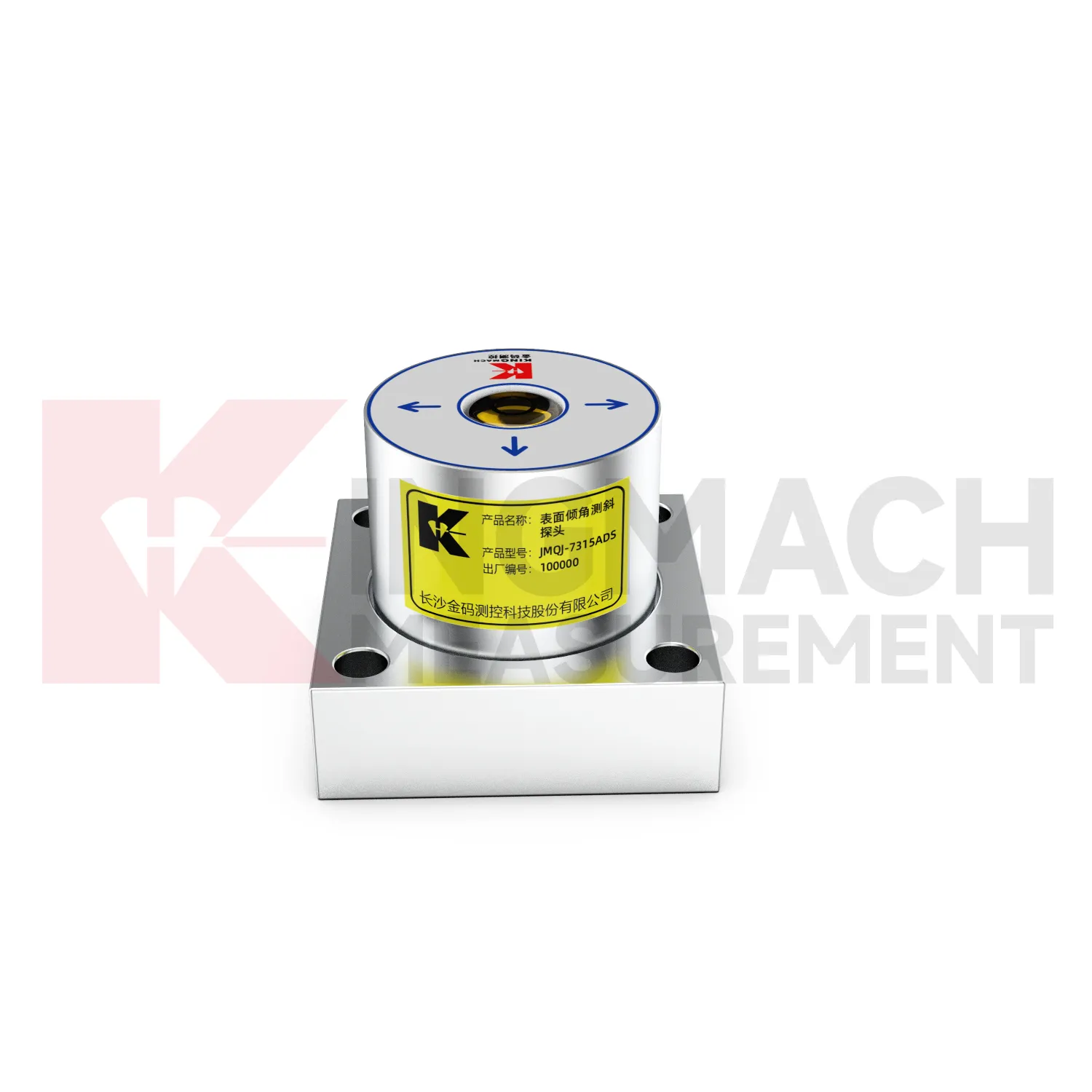
Railway and subway projects use Vertical In-Place Inclinometer System to observe trackside structures, retaining walls, tunnel linings, station structures, and embankment slopes. JMQJ-7315ADS supports wired RS485 acquisition, while JMQJ-7315RTU can reduce cable work through wireless 4G transmission. For underground or borehole deformation, JMQJ-7915ATS can provide multi-point inclinometer measurements. Tilt data should be interpreted with train operation, vibration, settlement, displacement, lining inspection, groundwater, and construction stage. Railway environments place strict demands on mounting protection and data continuity because access windows may be short. A good record connects each sensor with chainage, side, axis, structural member, and baseline reading. That way a tilt trend can be quickly compared with maintenance work or nearby deformation instruments.
The future of Vertical In-Place Inclinometer System
Manual and automated methods will continue to coexist in future Vertical In-Place Inclinometer System programs. JMZX-7100L supports APP reading, Bluetooth transmission, large storage, data download, and post-processing software for sliding inclinometer surveys. Fixed products such as JMQJ-7315ADS and JMQJ-7315RTU support automated structural tilt monitoring. In practice, a site may need both. Automated sensors can watch key points continuously, while manual inclinometer profiling can confirm deeper deformation at scheduled intervals. Future monitoring plans should define how manual profiles and automated curves are compared, who reviews differences, and how field notes are stored. This mixed approach is useful in slopes, ports, foundation pits, dams, and underground works where access and risk change over time.
Care & Maintenance of Vertical In-Place Inclinometer System
Battery and power checks keep Vertical In-Place Inclinometer System reliable in remote monitoring. JMQJ-7315RTU uses a 3.6V 38AH battery, while other instruments use DC 9V to 24V power or acquisition modules with standby and operating power modes. Maintenance staff should record battery status, power supply voltage, sleep interval, measurement interval, and any power outage. For low-power systems, confirm that sensors wake correctly during scheduled measurement. For wired cabinets, inspect terminals, fuses, grounding, moisture, and cable strain. A low-voltage condition can create missing data or unstable communication before a total failure appears. Power records are especially important for slopes, bridges, railways, and dams where access may be limited after installation.
Kingmach Vertical In-Place Inclinometer System
Kingmach Vertical In-Place Inclinometer System help turn difficult-to-observe deformation into repeatable engineering evidence. Hidden parts of structures are often the hardest to judge: deep soil, buried retaining systems, bridge substructures, railway bases, foundation pit walls, and underground construction zones. Tilt measurement gives engineers a way to see angular change before visible damage becomes obvious. The product category is used in bridges, tunnels, slopes, buildings, foundation pits, geological hazard areas, railways, dams, embankments, port engineering, and other structural scenarios. The monitoring record should connect each sensor to a drawing location, axis label, baseline date, power source, communication path, and related construction activity. Without that context, even a precise angle may be hard to interpret. With it, tilt data can support timely inspection and measured engineering decisions.
FAQ
Q: How often should Vertical In-Place Inclinometer System be inspected?
A: Inspection frequency depends on risk, access, construction stage, and deformation speed; active excavation or storm periods often need closer review.Q: What maintenance is needed for wireless tilt units?
A: Check battery status, antenna condition, upload timing, enclosure seals, point label, and platform channel naming.Q: What causes false tilt changes?
A: Loose mounting, disturbed cables, water entry, temperature effects, power faults, channel mistakes, or inconsistent manual reading can affect the record.Q: How should replacement be handled?
A: Record old and new model, serial number, range, baseline, reason, date, axis direction, channel name, and first stable value after replacement.Q: What makes tilt data useful over many years?
A: Consistent point naming, stable baselines, clear installation photos, protected hardware, visible maintenance records, and comparison with related site data.
Reviews
Matthew Garcia
Instrumentation cables are durable and perform well even in harsh environments. Will definitely order again.
Ryan Lewis
Fast delivery and excellent product quality. The accelerometers and tiltmeters are highly reliable. Strongly recommend this company.
Latest Inquiries
To protect the privacy of our buyers, only public service email domains like Gmail, Yahoo, and MSN will be displayed. Additionally, only a limited portion of the inquiry content will be shown.
Amelia***@gmail.comSingapore
Hello, I am looking for visualization software for monitoring system data analysis. Please let me kn...
Emma***@gmail.comCanada
Dear Sir/Madam, we are interested in displacement transducers and settlement sensors for a geotechni...